
Saturday, May 7, 2011
CHAPTER.18- HAWAII
One of the largest industries of the Hawaiian Islands is tourism. Los Angeles also has a large tourism industry. In fact, Tourism in Los Angeles's largest industry in terms of job creation. In 2007, 456,000 jobs were created in the tourism and hospitality industry. Over 25 million people visit L.A each year! LAX is the city's international airport and is the sixth busiest in the world. Most oversees visitors come from Australia as of 2010, however L.A is a popular destination for visitors from all over Asia and Europe. According to Frommer's guide to Los Angeles, some tourist attractions include: Paramount Studios, Hollywood Forever Cemetery, La Brea Tar Pits, Beverly Hills, Hollywood Walk of Fame, and the Santa Monica Pier, among others.
CHAPTER.16- THE NORTH PACIFIC COAST
Seattle is known as the world's largest company town. This is because of the huge number of people who are employed by such companies as Boeing and Microsoft and the impact they have on the local economy. There are several large employers in Los Angeles as well. The largest employer in L.A is Kroger Co. who own local supermarkets such as Ralphs, and other markets around the country. Interestingly, Boeing is also a significant employer in Los Angeles, employing 14,400 people as of 2009. Entertainment companies are also huge employers in L.A., Walt Disney being the largest with 11,200 employees. Below is a list of the largest employers in Los Angeles County in 2009.
Largest Employers in Los Angeles County, 2009
Source: http://www.laalmanac.com/employment/em21e.htm
Largest Employers in Los Angeles County, 2009
| Employer | Number of Employees |
| Kroger Co. | 140,000 |
| County of Los Angeles | 109,500 |
| Los Angeles Unified School District | 104,900 |
| City of Los Angeles | 56,200 |
| Federal Government* | 48,100 |
| Kaiser Permanente | 34,100 |
| State of California (non-education) | 30,500 |
| University of California, Los Angeles | 28,400 |
| Northrop Grumman Corp. | 19,100 |
| Boeing Co. | 14,400 |
| Long Beach Unified School District | 13,100 |
| Target Corp. | 13,000 |
| University of Southern California | 13,000 |
| Bank of America | 12,200** |
| Walt Disney Co. | 11,200** |
| Home Depot | 10,000 |
| Metropolitan Transit Authority (L.A. Co.) | 9,700 |
| Providence Health & Services | 9,700 |
| Vons | 9,600 |
| Cedars-Sinai Medical Center | 9,300 |
| Wells Fargo | 9,100 |
| ABM Industries Inc. | 9,000 |
| AT&T Inc. | 8,900 |
| California Institute of Technology | 8,500 |
| Fedex Corp. | 8,500 |
| Albertsons Southern California Region | 7,400** |
| Catholic Healthcare West | 7,200 |
| Edison International | 6,700** |
| Amgen Inc. | 6,500 |
| City of Long Beach | 6,300 |
| Washington Mutual Inc. (now Chase) | 6,000** |
| Costco Wholesale | 5,500 |
| UPS | 5,100 |
Sunday, May 1, 2011
CHAPTER.15- CALIFORNIA
Los Angeles is the most populated city in California, and the second most populated in the country. The city is one of two urban hubs in the state, along with San Francisco to the north. The landscape of the city was shaped by the family automobile (a characteristic that makes L.A different than the more densely populated cities of the East). This gave people greater flexibility when deciding where to live because they didn't necessarily have to be located by public transportation, but it has also contributed to the congestion of the city and the spread out landscape. The urban landscape of L.A is much more spread out than East Coast cities such as New York, Philadelphia, and Washington D.C. Some interesting statistics regarding L.A's car culture include:
- Over half the central part of L.A. is either road or parking designated
- L.A has more cars per household than any other city in the United States
- According to Forbes, L.A has worse traffic congestion than any other city in America
- The L.A. auto show started in 1907, and is now one of the biggest in the world, and the biggest on the West Coast

Saturday, April 30, 2011
CHAPTER.14- The Southwest Border Area
We learned from our textbook reading that the Los Angeles area is home to more American Indian residents than any other city in the country. However, Hispanic Americans far outnumber the number of American Indians. More than 3 million Spanish-heritage people reside in the Los Angeles area according to the text. L.A. is the largest Spanish culture north of Mexico City! Living in Los Angeles, it is obvious the huge impact Hispanic Americans have on the city's culture, economy and politics. Our Mayor is of Hispanic descent. locally and nationwide, immigration issues are one of the most controversial topics discussed today. There are over 2.3 million Hispanic owned business in the United States, many of them headquartered in Los Angeles. There is no denying the impact Hispanic Americans have had on the culture of Los Angeles. From restaurants and markets specializing in food from countries all over Latin America (and I'm not talking about Baja Fresh :/) to local artists who pay tribute to Hispanic history and culture, as well as the Museum of Latin American Art in Long Beach to the Hispanic majority community of East L.A., Hispanic Americans influence the culture and way of life in L.A.

Museum of Latin American Art in Long Beach:
Saturday, April 23, 2011
CHAPTER.13- THE EMPTY INTERIOR
The Empty Interior is home to numerous national parks, which are the best know use of the vast governmental land resource. The Bureau of Land Management holds the largest share and the U.S Forest Service is the second largest U.S. federal land holder. The U.S Forest Service is in charge of the Angeles National Forest in the Los Angeles area. This forest contains over 1000 square miles of open space to the residents and visitors of L.A. With a land area of 655,387 acres and 697 miles of trails, the forest offers natural scenery and numerous recreational activities. The forest is located north of Los Angeles in the San Gabriel mountains.

Photo Source: http://www.fs.usda.gov/wps/portal/fsinternet/
Photo Source: http://www.fs.usda.gov/wps/portal/fsinternet/
Sunday, April 17, 2011
CHAPTER.12- THE GREAT PLAINS AND PRAIRIES
The great plains is no stranger to extreme weather. From the 20 year drought cycle to tornadoes and hail, this region of the United States has experienced all that mother nature has to offer. Los Angeles experiences a very moderate Mediterranean subtropical climate, but as we all know, the weather can also be described as "extreme" occasionally. According to USA Today, there were 41 documented tornadoes in Los Angeles country between 1950 and 2004, more than any other city in the state of California. Although these tornadoes are generally very minor (f-0/f-1) compared to the ones in the great plains, there have been 5 tornadoes rated f-2 on the Fujita scale, which measures the strength of these storms. Hail is far more common is Los Angeles than tornadoes. These stones of ice water fall when the elements are right, and are fairly common during our winter storms. Of course, the hail we experience in L.A is rarely the golf ball size hail that falls on the great plains and can devastate crops and property.

Wednesday, April 6, 2011
CHAPTER.11- THE AGRICULTURAL CORE
This chapter discusses trends in the number and size of farms in the agricultural core. The number of farms has decreased in last century, but the average farm size has increased. The question is whether or not this trend is also the case in the Los Angeles area. Between 1900 and 2002 the number of farms decreased from 6,577 to 1,543. This decrease was not constant, as there was actually an increase in the number of farms through the 1940's, followed by a steady decrease until 1982 when there was a small increase in the number of farms. The number of farms then continued to decrease until recently when the number of farms in Los Angeles increased between 1997 and 2002 from 1,226 to 1,543. Average farm size has decreased since 1900 from an average size of 136 acres to 72 acres. Between 1964 and 1972 there was a sharp increase in farm size, reaching a peak average size of 223 acres. The overall decrease in the average farm size in the last century differs from the trends of the agricultural core. This is just another way Los Angeles differs from the rest of the country! 
Photo Source: http://ucanr.org/blogs/losangelesagriculture/index.cfm?tagnamehttp://ucanr.org/blogs/losangelesagriculture/index.cfm?tagname=farm
Photo Source: http://ucanr.org/blogs/losangelesagriculture/index.cfm?tagnamehttp://ucanr.org/blogs/losangelesagriculture/index.cfm?tagname=farm
Sunday, March 27, 2011
CHAPTER.10- THE SOUTHERN COASTLANDS
Some of the largest ports in the United States are located in the southern coastlands. As evident from our reading, these ports have been hugely important in the development of this region of the United States. the port of Los Angeles, is also very important, and along with the port of Long Beach in a huge contributor to our local economy. The port opened in December 1907 and in 2005 was the busiest container port in the United States. The port complex covers an area of 7,500 acres, with a harbor covering 3,300 acres. Over 16,000 people are employed by the harbor, impacting out local economy, as well as our local politics, infrastructure, and way of life. Cruise ships also dock at Los Angeles harbor, including the famous Queen Mary 2, which is the largest cruise ship to ever sail from Los Angeles. The port have passenger traffic of over 1 million people annually, including tourist who contribute to our economy by patronizing local businesses and attractions.
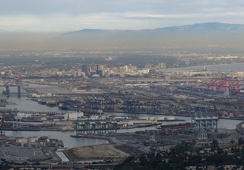
L.A Port
Photograph source: http://en.wikipedia.org/wiki/File:LA-port%2BLong-Beach1.jpg

L.A Port
Photograph source: http://en.wikipedia.org/wiki/File:LA-port%2BLong-Beach1.jpg
Saturday, March 19, 2011
CH.9- THE CHANGING SOUTH
There are some dark periods in the history of the south, plagued with prejudice and segregation of African Americans. Los Angeles is no stranger to these attributes. In 1965, the Watts Riots, which lasted 6 days and claimed the life of 34 people while injuring over 1,000 others, was viewed by many as a reaction to the racial injustices suffered by African Americans in the L.A area through police brutality, as well as job and housing discrimination.
 SOURCE: http://www.negroartist.com/WATTS%20RIOTS/slides/A%20montage%20of%20pictures%20of%20the%20Watts%20riots%20in%20Los%20Angeles,%20August%2011%2015,%201965.jpg
This photograph depicts some of the looting and destruction caused by the 6 days of riots, resulting in over $40 million of damage.
SOURCE: http://www.negroartist.com/WATTS%20RIOTS/slides/A%20montage%20of%20pictures%20of%20the%20Watts%20riots%20in%20Los%20Angeles,%20August%2011%2015,%201965.jpgThis photograph depicts some of the looting and destruction caused by the 6 days of riots, resulting in over $40 million of damage.
Wednesday, March 16, 2011
CHAPTER.8- APPALACHIA AND THE OZARKS
This chapter went into great deal about the topography of this region of the United States. Los Angeles's topography s very different, but still as interesting. The Los Angeles area covers nearly 500 square miles, with 470 square miles of land, and 30 square miles of water. The highest point is Mount Lukens, which reaches 5080 feet and is in the northeast part of the San Fernando Valley area of L.A. The majority of Los Angeles lies on a hilly coastal plain with the Pacific Ocean to the south and west.

source: http://www.theregister.co.uk/2009/06/30/nasa_japan_release_99_complete_topographic_map/
source: http://www.theregister.co.uk/2009/06/30/nasa_japan_release_99_complete_topographic_map/
Tuesday, March 15, 2011
CHAPTER.7- THE BYPASSED EAST
After reading about the importance of agriculture in the bypassed east, I decided to do some research on agriculture in the Los Angeles area. While Los Angeles is mainly an urbanized area, there is a significant amount of agriculture produced in our county! The Antelope Valley is one part of the country which has a significant amount of agriculture. Crops produced include: alfalfa, carrots, potatoes, peaches, grapes and nectarines, according to the University of California Agriculture and Natural Resources website. In L.A county, over $250,000,0000 of crops are produced each year. Agriculture is also significant in our surrounding areas, such as Ventura County, which takes advantage of our southern California climate. All of the local produce grown is why there are so many farmers markets in Los Angeles, enabling us to talk one on one with the people who grow our food, while saving money and resources by cutting down on transportation costs and resources.
 Source: http://celosangeles.ucdavis.edu/Agriculture/
Source: http://celosangeles.ucdavis.edu/Agriculture/
Saturday, February 26, 2011
CH.5- THE NORTH AMERICAN MANUFACTURING CORE
Although the manufacturing core of the United States is in the northeast, Los Angeles is the home to plenty of manufacturing. Industries include: Apparel, Computer and Electronics, Transportation products, Fabricated Metal products, Food products, and Furniture- no wonder Los Angeles is home to the nation's largest port! One well known apparel manufacturer based in Los Angeles is American Apparel, which is known around the world. American Apparel owns an 800,000 square foot factory in downtown Los Angeles, and employees 4,000 people.
SOURCE: americanapparel.com
SOURCE: americanapparel.com
Made in Downtown LA Vertically Integrated Manufacturing |
Saturday, February 19, 2011
CHAPTER.4- MEGALOPOLIS
Los Angeles definitely feels like a megalopolis. The Los Angeles-Long Beach-Riverside area is one big metro area, thanks to Metropolitan Coalescence which makes L.A and it's surrounding cities feel like one huge city with numerous city centers. Spatial Interaction in Los Angeles is highly important, because so many of us who live in L.A have to get around our megalopolis and go from one city to another. Los Angeles experiences many of the problems other megalopolis encounter including: congestion, polution, and overcrowding, among others.
The Los Angeles Megalopolis
The Los Angeles Megalopolis
Thursday, February 17, 2011
CHAPTER.3- FOUNDATIONS OF HUMAN ACTIVITY
Los Angeles has a very diverse population thanks to the huge number of immigrants who call L.A home. Due to this immigration, the ethnic character of many of the cities communities have changed over time. Due to the vast immigration into Los Angeles, all of the following religions are widely practiced in our city: Islam, Buddhism, Hinduism, Zoroastrianism, Sikhism, Baha'i, various Eastern Orthodox Churches, Sufism, among others.
Here is some interesting information relating to the demographics of Los Angeles which relate to chapter. 3, courtesy of http://en.wikipedia.org/wiki/Los_Angeles#Demographics.
According to the 2006–08 American Community Survey, the racial composition of Los Angeles was as follows:
Here is some interesting information relating to the demographics of Los Angeles which relate to chapter. 3, courtesy of http://en.wikipedia.org/wiki/Los_Angeles#Demographics.
According to the 2006–08 American Community Survey, the racial composition of Los Angeles was as follows:
- White: 49.5% (Non-Hispanic Whites: 29.4%)
- Black or African American: 9.9%
- Native American: 0.6%
- Asian: 10.4%
- Native Hawaiian and Other Pacific Islander: 0.2%
- Some other race: 26.5%
- Two or more races: 2.9%
- Hispanic or Latino (of any race): 48.4%
| Historical populations | ||
|---|---|---|
| Year | Pop. | %± |
| 1850 | 1,610 | — |
| 1860 | 4,385 | 172.4% |
| 1870 | 5,728 | 30.6% |
| 1880 | 11,183 | 95.2% |
| 1890 | 50,395 | 350.6% |
| 1900 | 102,479 | 103.4% |
| 1910 | 319,198 | 211.5% |
| 1920 | 576,673 | 80.7% |
| 1930 | 1,238,048 | 114.7% |
| 1940 | 1,504,277 | 21.5% |
| 1950 | 1,970,358 | 31.0% |
| 1960 | 2,479,015 | 25.8% |
| 1970 | 2,816,061 | 13.6% |
| 1980 | 2,966,850 | 5.4% |
| 1990 | 3,485,398 | 17.5% |
| 2000 | 3,694,820 | 6.0% |
| 2009 | 3,831,868 | 3.7% |
Monday, February 7, 2011
CHAPTER.2- GEOGRAPHIC PATTERNS OF THE PHYSICAL ENVIRONMENT
One of the "recent" landform processes that helped shape North America is earthquakes. Earthquakes are a part of life in Los Angeles, effecting the way our buildings are roads are built, as well as the safety education we aquire in school. The largest fault that effects Los Angeles is the San Andreas Fault, which runs over 800 miles through california. Although the fault doesn't actually run through L.A, the power of one of the earthquakes it produces has the potential to shake L.A. like never before. Below is a list of significant earthquakes to hit the Los Angeles area:
SOURCE: http://earthquake.usgs.gov/regional/sca/la_eqs.php

YEAR MN DY HRMINSEC  LATITUTE  LONGITUDE MAG   DEPTH        NAME
---- -- -- --------  --------  --------- ------ -----  ---------------

1920                                     ml=4.9
1930                                     ml=5.2
1933  3 11 015407.80 33 37.00 -117 58.00 mw=6.4  0.00 Long Beach
1938  5 31 083455.41 33 41.93 -117 30.64 ml=5.2 10.00
1941 10 22 065718.50 33 49.00 -118 13.00 ml=4.8  0.00
1941 11 14 084136.30 33 47.00 -118 15.00 ml=4.8  0.00
1952  8 23 100907.15 34 31.16 -118 11.89    5.2 13.10
1969 10 24 082912.11 33 17.46 -119 11.56    5.1 10.00
1970  9 12 143052.98 34 16.19 -117 32.40 ml=5.2  8.00 Lytle Creek
1971  2  9 140041.83 34 24.67 -118 24.04 mw=6.7  8.40 San Fernando (Sylmar)
1973  2 21 144557.30 34  3.89 -119  2.10 ml=5.9  8.00 Point Mugu
1979  1  1 231438.94 33 56.66 -118 40.88 ml=5.2 11.28 Malibu
1981  9  4 155050.13 33 39.09 -119  5.58 mw=6.0  6.00 Santa Barbara Island
1987 10  1 144220.02 34  3.68 -118  4.71 ml=5.9  9.53 Whittier Narrows
1988 12  3 113826.44 34  9.06 -118  7.81 ml=5.0 14.27 Pasadena
1989  1 19 065328.84 33 55.12 -118 37.65 ml=5.0 11.86 Malibu
1990  2 28 234336.75 34  8.62 -117 41.84 ml=5.3  4.49 Upland
1991  6 28 144354.66 34 16.19 -117 59.58 mw=5.8  9.15 Sierra Madre
1994  1 17 123055.39 34 12.80 -118 32.22 mw=6.7 18.40 Northridge
SOURCE: http://earthquake.usgs.gov/regional/sca/la_eqs.php
Tuesday, February 1, 2011
CHAPTER 1- REGIONS AND THEMES
For this first post, I want to concentrate on the climatic region of Los Angeles.
Los Angeles enjoys a Subtropical- Mediterranean climate. The climate is characterized by warm to hot, dry summers and mild to cool, wet winters. The average temperature during the day in downtown Los Angeles is 75 degrees; the average overnight temperature is 57 degrees. The average annual precipitation total is just over 15 inches, with February usually being the wettest month of the year. The chart below provides the total inches of rain Los Angeles has received over the last decade. As you can see, the 2004-2005 season was unusually wet, while the 2006-2007 season was unbearably dry!
SOURCE: http://www.laalmanac.com/weather/we13.htm
Los Angeles enjoys a Subtropical- Mediterranean climate. The climate is characterized by warm to hot, dry summers and mild to cool, wet winters. The average temperature during the day in downtown Los Angeles is 75 degrees; the average overnight temperature is 57 degrees. The average annual precipitation total is just over 15 inches, with February usually being the wettest month of the year. The chart below provides the total inches of rain Los Angeles has received over the last decade. As you can see, the 2004-2005 season was unusually wet, while the 2006-2007 season was unbearably dry!
| Season (July 1-June 30) | Total Inches of Rainfall | Inches Above/Below (+/-) 132 Year Average |
2008-2009 | 9.08 | -5.90 |
2007-2008 | 13.53 | -1.45 |
2006-2007 | 3.21 | -11.77 |
2005-2006 | 13.19 | -1.79 |
2004-2005 | 37.96 | +22.98 |
2003-2004 | 9.25 | -5.73 |
2002-2003 | 16.42 | +1.44 |
2001-2002 | 4.42 | -10.56 |
2000-2001 | 17.94 | +2.96 |
SOURCE: http://www.laalmanac.com/weather/we13.htm
Subscribe to:
Comments (Atom)